Roadways:
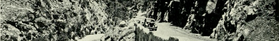
The only roadway to the South Fork of the Kings River is California State Route 180. Originally envisioned as a possible Trans-sierra route from Fresno to Independence.
For more information about the history of the initial construction of CA-180, and subsequent adjustments/realignments check out the following links:
-
-
- California Highways: State Route 180
- Gribblenation: California State Route 180 east of Fresno to Cedar Grove (Kings Canyon Highway) (1905 – 2017)
- Gribblenation: Onion Valley Road; former California State Route 180 to Kearsarge Pass (1905 – 2020)
- Gribblenation: California State Route 180 Kings Canyon Road Expressway and Sequoia-Kings Canyon Freeway (1990’s – Present)
-
Campgrounds:
The initial 4 campgrounds (now named Sheep Creek, Sentinel, Canyon View, & Moraine) were constructed and maintained by the National Forest Service from 1937-1965. After which, and through the present, they have been operated and maintained by the National Park Service.
[CHALLENGE OF THE BIG TREES by Lary M. Dilsaver and William C. Tweed, ©1990, Sequoia Natural History Association, Inc., Chapters 7-8]
Forest Fires:
| Year | Name | Cause | Location Description |
| 1916 | Miscellaneous | Upstream along Redwood Creek South of 180 | |
| 1917 | Lightning | Near Boole Tree | |
| 1917 | Miscellaneous | Middle Fork upstream from Confluence | |
| 1917 | Lightning | West Side of Lewis Creek, North of Road | |
| 1921 | Lightning | Near Head Waters of Wren Creek, upstream from Grizzly | |
| 1921 | Miscellaneous | South side between Lewis Creek & Deer Cove | |
| 1928 | Miscellaneous | From Boole Tree, Downstream | |
| 1931 | Miscellaneous | Indian, Ten Mile, & Redwood Creeks Drainages from Hume Rd to Yucca Point. | |
| 1932 | Miscellaneous | Downstream from Grizzly Creek | |
| 1933 | Miscellaneous | North side between Windy Gulch & Grizzly | |
| 1934 | Lightning | Upslope between Hotel & Granite Creeks | |
| 1934 | Miscellaneous | Downstream from Windy Gulch down past Convict Flats | |
| 1950 | DEER COVE | Smoking | Along Deer Cove Creek & Trail |
| 1950 | EAGLE PEA | Lightning | North side between Windy Gulch & Downstream from Grizzly |
| 1950 | Lightning | Along Wren Creek | |
| 1955 | UNKNOWN | Unknown/ Unidentified | Northside Near Convict Flats |
| 1955 | MCGEE | Miscellaneous | Visible from Mcgee Vista facing West |
| 1955 | Miscellaneous | Indian Basin Meadow | |
| 1955 | SENTINAL RIDGE | Lightning | Southside of Sentinel Ridge, West of Roaring River. |
| 1959 | LEWIS CRK | Lightning | Near Cedar Grove Overlook |
| 1961 | NORTH MTN | Lightning | Upstream from Hotel Creek |
| 1962 | Miscellaneous | Northside From Confluence to almost Convict Flats | |
| 1966 | Lightning | Spring, Garlic Meadow & Rough Creek Drainages | |
| 1970 | BUBBS CRE | Lightning | Uplope from Bubbs Creek |
| 1971 | UNKNOWN | Unknown/ Unidentified | Between Deer Cove Trail & East Fork Grizzly Creek along Happy Gap Trail |
| 1973 | SO SENTIN | Lightning | South of Sentinel Ridge and downstream from Roaring River |
| 1973 | MORAINE C | Lightning | Near confluence of Moraine creek & Roaring River |
| 1975 | Arson | Northside Near Convict Flats | |
| 1976 | SPHINX | Campfire | Along Bubbs Creek between Sphinx Creek and North Guard Creek |
| 1979 | KENNEDY | Lightning | Downstream from East Fork Lewis Creek along Lewis Creek Trail to Kennedy Pass |
| 1979 | SENTINEL | Lightning | South of intersection of Sentinel Ridge & Roaring River |
| 1980 | LEWIS CRK | Equipment Use | Along Lewis Creek Drainage |
| 1980 | ROARING | Lightning | Along Roaring River South of Sugarloaf Creek. |
| 1980 | TENT | Lightning | Along Copper Creek Trail Near Tent Meadow |
| 1982 | Lightning | Upslope and around corner downstream from Grizzly Falls | |
| 1985 | CONVERSE | Smoking | North of converse basin at end of Converse Road |
| 1986 | DEER | Smoking | Northside From Confluence to Kings River Trailhead & Verplank Creek |
| 1988 | LEWIS CR | Lightning | Upslope and between Lewis Creek and Deer Cove Trail |
| 1988 | OBELISK | Lightning | Crossing Middle Fork along Tombstone Creek From Obelisk to Wren Peak. |
| 1990 | AVALANCHE | Lightning | Southside, Upstream from Roaring River |
| 1993 | BUCK PEAK | Lightning | Near Roads End along Copper Creek Trail |
| 1993 | HELIPORTW | Escaped Prescribed Burn | Cedar Grove Heliport |
| 1994 | GARLIC | Lightning | Downstream from Middle Fork Confluence by Garlic Meadow Creek |
| 1994 | GRANITE | Lightning | Northside along Granite Creek |
| 1995 | MOTORNATU | Escaped Prescribed Burn | Upstream from entrance to Motor Nature Trail |
| 1997 | CHOKE | Lightning | Upslope from Grizzly Creek, Downstream from Frypan Meadow |
| 2000 | ROADS END | Arson | East of Roads End, Northside of South Fork |
| 2000 | MILLWOOD | Equipment Use | Downslope from SR-180, West of Sequoia Lake |
| 2002 | RIVER | Arson | Northside of South fork along River & Motor Nature Trails, East of Lodge & Ranger Housing |
| 2005 | COMB | Lightning | Upslope northside of South fork across ridge from Deer Cove to Granite Creek upstream |
| 2006 | ROARING | Lightning | Upslope, South side, South Fork from Sheep Creek to Roaring River, south to Sentinel ridgeline. |
| 2006 | RIDGE | Lightning | Upslope, South side, South Fork from Sheep Creek to Roaring River, south to Sentinel ridgeline. |
| 2010 | SHEEP COMPLEX | Lightning | Upslope southside of South Fork, from Grizzly Falls to Sheep Creek. |
| 2015 | ROUGH | Lightning | North of Grant Grove, East of Pine Flat Headwaters to upstream from Hotel Creek and North to Rancheria Creek and Crown valley Trail |
| 2016 | SENTINEL | Lightning | Along Sheep creek near lookout peak & Sentinel ridge |
| 2018 | NORTH BUBBS | Lightning | Northside along Bubbs Creek |
| 2021 | KNP Complex | Lightning | Along General’s Highway south of Grant’s Grove to the East Fork of the Kaweah River |
| 2021 | BOYDEN 1 | Debris | Northside of South Fork, across and downstream from Boyden’s Cavern |